
After nearly a year of research, development, and community outreach, the City of Tualatin Parks and Recreation Department shared its vision for multiple future recreation sites throughout the Basalt Creek development district.
Think greenways, trails, natural areas: multiple parks with playgrounds, picnic shelters, and athletic fields with Basalt Creek, at the bottom of a steep canyon, slicing the total development area roughly in half.
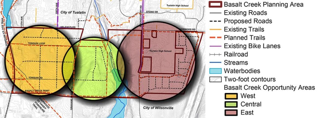
“Basalt Creek will be a major employment area for the city as well as a home for established residents. (It will) address an unmet need in the area. It would be critical to connect each user group to parks and recreation in meaningful ways,” said Rich Mueller, Parks planning and development manager.
Tualatin City Council members unanimously accepted the draft plan in January without comment or questions, clearing the way for future adoption consideration. Accepting rather than adopting the plan provides guidance to city planners while leaving space for further public input as the project evolves.
“The Basalt Creek Parks and Recreation plan makes it possible to expand parks and recreation facilities and services to this newest part of the city,” said project manager Rachel Edmonds, referring to the 367-acre Basalt Creek planning area between Tualatin and Wilsonville.
The plan identifies three potential recreation zones spanning the development district and integrated with its residential, commercial, and industrial zones.
Planners conceptualized each segment using community feedback gathered from more than 700 people and tailored them to match the proposed development, infrastructure, and topography of each area including some ecologically sensitive protected stretches.
“The west side is generally envisioned as a place for connections for employees providing safe places to walk and bike, before, during, and after work hours,” project planner Rachel Edmonds said. Its bike and walking paths will link up with the regional Ice Age Tonquin Trail.
In the largely residential east section, planners envision teaming up with future residents to build a series of homeowner association parks. The east section would also house stormwater areas.
Edmonds said the midsection is going to support a future neighborhood-style park built to serve nearby residents and employees of Basalt Creek. It could house a 10-acre park and sports complex accessible from the east side of Graham’s Ferry Road where site conditions are less attractive for industrial investment and development.
A new sports complex with additional athletic fields was a frequent request during outreach. Planners surveyed the community in both English and Spanish to pinpoint their needs.
The center section, through which the creek runs, is truly the centerpiece. A north-south trail running along the top of the canyon’s west side would give visitors views of the creek and wetlands without disturbing the environmentally fragile buffer zone.
“Many people have not seen Basalt Creek and it’s really a very beautiful creek and wetland area,” Parks and Recreation director Ross Hoover said.
The park plan is built on both the 2018 systems plan and Basalt Creek comprehensive plan.
“This is not a land-use action. This is purely an acceptance step,” Hoover said. “It’s an affirmation from the Mayor and City Council that this is generally a plan that can move forward and at the same time tell staff that yes, we can start to think about where some potential areas of acquisition for future parks might be and allows us to continue to work with landowners in the Basalt Creek area through that process.”